Map of Pompeii Before the Eruption: The City in 79 AD
What Pompeii Looked Like Before the Eruption
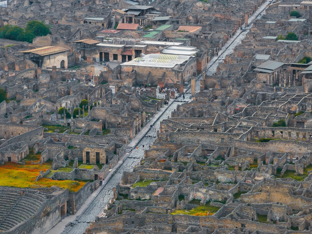
Before the eruption of 79 AD, Pompeii was a walled port city of roughly 11,000 to 15,000 people, built on a low volcanic ridge beside the Sarno river and close to the coast of the Bay of Naples. Its paved streets formed a rough grid centered on the Forum, with two theatres, a large amphitheatre, public baths, temples, and rows of shops, bakeries, and houses. This page sketches a map of Pompeii before the eruption so you can picture the living city beneath the ruins.
For the modern site plan and how to navigate it on a visit, see our map of Pompeii. To see how the buildings looked standing rather than in ruins, see Pompeii reconstructed.
A Walled Port City on the Sarno
In 79 AD Pompeii covered about 64 to 66 hectares, enclosed by a defensive wall pierced by gates such as the Porta Marina, Porta Ercolano, and Porta Nola. The city stood much nearer the sea than the ruins do today; the eruption and later river sediment pushed the coastline outward by roughly two kilometers. A port on the Sarno linked Pompeii to coastal trade, and the city grew wealthy on wine, olive oil, fish sauce (garum), and textiles.
The street plan was a grid, though an irregular one that grew over centuries. The two great east–west arteries were the Via dell'Abbondanza and the Via di Nola, lined with shops, fountains, and stepping stones that let pedestrians cross without stepping into the water and waste that ran along the paving.
The Nine Regiones and the Insulae
To describe the city, archaeologists divide it into nine regiones (districts). Each regio is split into numbered blocks called insulae, and each doorway within a block is numbered in turn, giving every building a precise three-part address (for example, Regio VI, Insula 15, doorway 1 for the House of the Vettii). This grid is the backbone of any map of Pompeii before the eruption and of the modern excavated plan.
The Main Districts and Landmarks
A walk across the pre-eruption city would have passed these key zones and monuments:
- The Forum — the civic and religious heart at the southwest, ringed by temples, the basilica (law court), and market buildings.
- Temple of Apollo and Temple of Jupiter — major sanctuaries on and beside the Forum.
- The Triangular Forum and the theatre district — home to the Large Theatre (open-air, ~5,000 seats) and the small roofed Odeon.
- The Amphitheatre — at the southeast corner, one of the oldest stone amphitheatres in the Roman world, seating around 20,000.
- The Stabian Baths and Forum Baths — public bathing complexes with hot, warm, and cold rooms.
- Grand houses — including the House of the Faun and the House of the Vettii, decorated with mosaics and frescoes.
- The city gates and walls — controlling the roads to Herculaneum, Nola, and the sea.
| Feature | Location in the city | Purpose |
|---|---|---|
| Forum | Southwest | Civic, legal, religious center |
| Large Theatre & Odeon | South (theatre district) | Performances |
| Amphitheatre | Southeast corner | Gladiatorial games |
| Stabian Baths | Center, on Via dell'Abbondanza | Public bathing |
| Porta Marina | West | Gate toward the old waterfront |
A Living Roman Town
Beyond its monuments, pre-eruption Pompeii was a busy, ordinary town: bakeries with stone mills, fast-food counters (thermopolia), laundries, a brothel, election slogans painted on walls, and gardens behind the houses. It was this everyday vitality — frozen mid-life — that makes the site so extraordinary. To explore that daily world further, read about Roman life in Pompeii and tour the standing reconstruction in Pompeii reconstructed.
Related Pages
- Map of Pompeii — The modern site plan and how to find your way around
- Pompeii Reconstructed — The buildings shown as they once stood
- The Ancient City — Overview of Pompeii's houses, streets, and art
- Roman Life in Pompeii — Daily life in the city before 79 AD
Pompeii: Small Group Tour with an Archaeologist
See it with an expert — a small-group walk through Pompeii led by a professional archaeologist.
Frequently Asked Questions
What did Pompeii look like before the eruption?
Before 79 AD, Pompeii was a thriving walled port city of roughly 11,000 to 15,000 people, set on a low ridge near the mouth of the Sarno river and close to the coast. It had paved streets laid out in a grid, a central Forum, two theatres, a large amphitheatre, public baths, temples, shops, bakeries, and grand private houses.
How was the ancient city of Pompeii organized?
Modern archaeologists divide Pompeii into nine zones called regiones, each subdivided into numbered blocks called insulae, with individual doorways numbered within them. This system gives every building a three-part address. The living city was centered on the Forum at the southwest, with main roads such as the Via dell'Abbondanza running across the urban grid.
Was Pompeii on the coast before the eruption?
Yes. Before 79 AD Pompeii sat near the sea, with a port serving the Sarno river and the Bay of Naples. The eruption and later sediment pushed the coastline outward, so the ruins now lie about two kilometers inland. The Porta Marina — the 'sea gate' — preserves the name and direction of the old waterfront.
How big was Pompeii before it was destroyed?
The walled city covered roughly 64 to 66 hectares (about 160 acres), enclosed by a defensive wall pierced by several gates. Population estimates range from about 11,000 to 15,000 residents, plus the people of the surrounding farms and villas. It was a mid-sized but prosperous Roman town, not a giant metropolis.