Pompeii Map — Interactive Guide to the Archaeological Site
Navigating the Ancient City
A good pompeii city map is essential before your visit. Understanding the layout of Pompeii will greatly enhance your experience. The archaeological site is vast — covering 66 hectares — and without a pompeii city plan, it is easy to miss key landmarks or become disoriented among the ancient streets. This guide will help you understand how the city is organized and plan an efficient walking route.
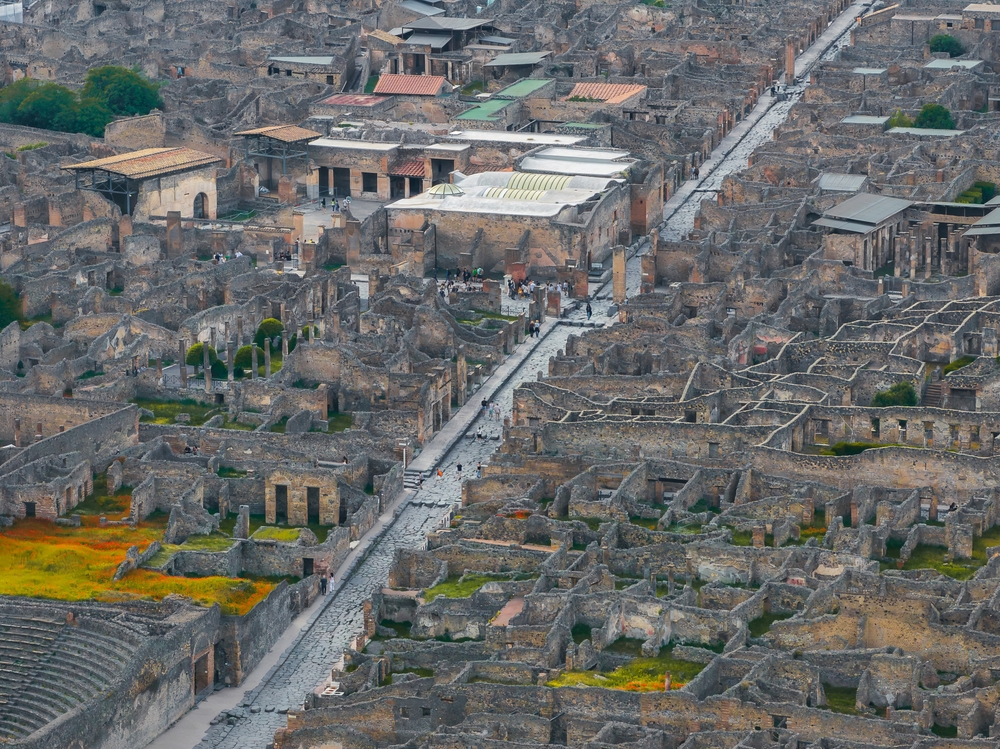
Any pompeii ancient city map reveals a remarkably organized urban grid that still impresses modern urban planners. Whether you are studying a pompeii old city map from early excavation records or viewing pompeii city on map through modern satellite imagery, the street layout is strikingly legible.
City Layout and Structure
Pompeii follows a modified Hippodamian grid plan, with two main east-west streets (decumani) intersected by north-south streets (cardines). The city is enclosed by walls approximately 3 kilometers in circumference, punctuated by eight gates that once controlled access to the city.
The Nine Regions
In the 1860s, archaeologist Giuseppe Fiorelli divided the excavated city into nine numbered regions (Regiones I through IX) for cataloging purposes. Each region is further subdivided into blocks (insulae) and individual building entrances. This system remains in use today and appears on all official site maps.
Regions VII and VIII form the heart of the city, containing the Forum, the major temples, the public baths, and many of the most famous houses. Most visitors spend the majority of their time in these central regions.
Regions I and II in the southeast contain the Amphitheatre, the Large Palaestra (exercise ground), and some magnificent houses including the House of the Menander and the Garden of the Fugitives.
Regions III, IV, and V in the northeast are less visited but contain fascinating residential neighborhoods and commercial areas, including several fullonicae (laundries) and pistrinae (bakeries) that illustrate daily life in the ancient city.
Regions VI and IX in the northwest include some of Pompeii's grandest houses, including the House of the Faun and the House of the Vettii, as well as the Villa of the Mysteries just outside the city walls.
Entrances and Access Points
The archaeological park has three main entrances:
Porta Marina (West Entrance) — The primary entrance, located closest to the Pompei Scavi - Villa dei Misteri train station. From here, you enter near the Forum and can immediately access the civic and religious heart of the city. This is the busiest entrance, especially in the morning.
Piazza Anfiteatro (East Entrance) — Located near the Amphitheatre, this entrance is often less crowded and provides a different perspective on the city. You can work your way westward toward the Forum, saving the most impressive civic buildings for the end of your visit.
Piazza Esedra (South Entrance) — A good compromise entrance that puts you in the center of the site, allowing easy access to both the Forum area and the eastern neighborhoods.
Recommended Walking Routes
The Classic Route (3 hours)
Start at Porta Marina and follow this route for the essential highlights:
- Enter via Porta Marina and walk to the Forum (5 minutes)
- Visit the Temple of Jupiter and the Macellum (market hall)
- Walk north on Via del Foro to the Forum Baths
- Continue to the House of the Faun (Region VI)
- Head to the House of the Vettii
- Walk east along Via di Nola to the Central Baths
- Turn south to the Stabian Baths
- Visit the Lupanar (brothel)
- Continue south to the Theatres (Large and Small)
- Return to Porta Marina via Via dell'Abbondanza
The Comprehensive Route (5 hours)
Follow the Classic Route, then add:
- Walk east on Via dell'Abbondanza to Region I
- Visit the House of the Menander
- Continue to the Amphitheatre and Large Palaestra
- See the Garden of the Fugitives (plaster casts)
- Walk to the Villa of the Mysteries (exit from Porta Marina side)
Key Streets
Via dell'Abbondanza — The main east-west thoroughfare running from the Forum to the Sarno Gate. This was Pompeii's commercial heart, lined with shops, taverns, and workshops. Visitors can still see painted shop signs and election notices on the walls.
Via di Stabia — The main north-south street connecting the Vesuvius Gate to the Stabian Gate. At its intersection with Via dell'Abbondanza stands one of the city's most important crossroads.
Via del Foro — Running north from the Forum, this elegant street was lined with some of the city's most important public buildings and leads to the House of the Faun.
Practical Map Tips
- Pick up a free paper map at the entrance ticket office
- Download the official Pompeii app (MyPompeii) for GPS-guided navigation
- Wear comfortable walking shoes — the ancient streets are made of uneven basalt cobblestones
- Some buildings are periodically closed for restoration; check the official website for current openings
- Shade is limited; bring sun protection and water, especially in summer
- Stepping stones in the streets were ancient pedestrian crossings, allowing Romans to cross without stepping in the water and waste that flowed through the streets
Frequently Asked Questions
How big is the Pompeii archaeological site?
The ancient city of Pompeii covers approximately 66 hectares (163 acres), of which about two-thirds (44 hectares) have been excavated. The site is roughly oval in shape, measuring about 1.2 km from east to west and 700 meters from north to south.
How is Pompeii organized on the map?
Pompeii is divided into 9 regions (Regiones I through IX), established by archaeologist Giuseppe Fiorelli in the 1860s. Each region is further divided into blocks (insulae) and individual buildings, creating an address system like 'Region VII, Insula 4, Entrance 31' for the House of the Faun.
Which entrance to Pompeii should I use?
The main entrance is Porta Marina, closest to the Pompei Scavi train station and the Forum. The Piazza Anfiteatro entrance is near the Amphitheatre and is often less crowded. The Piazza Esedra entrance provides access to the central area of the site.